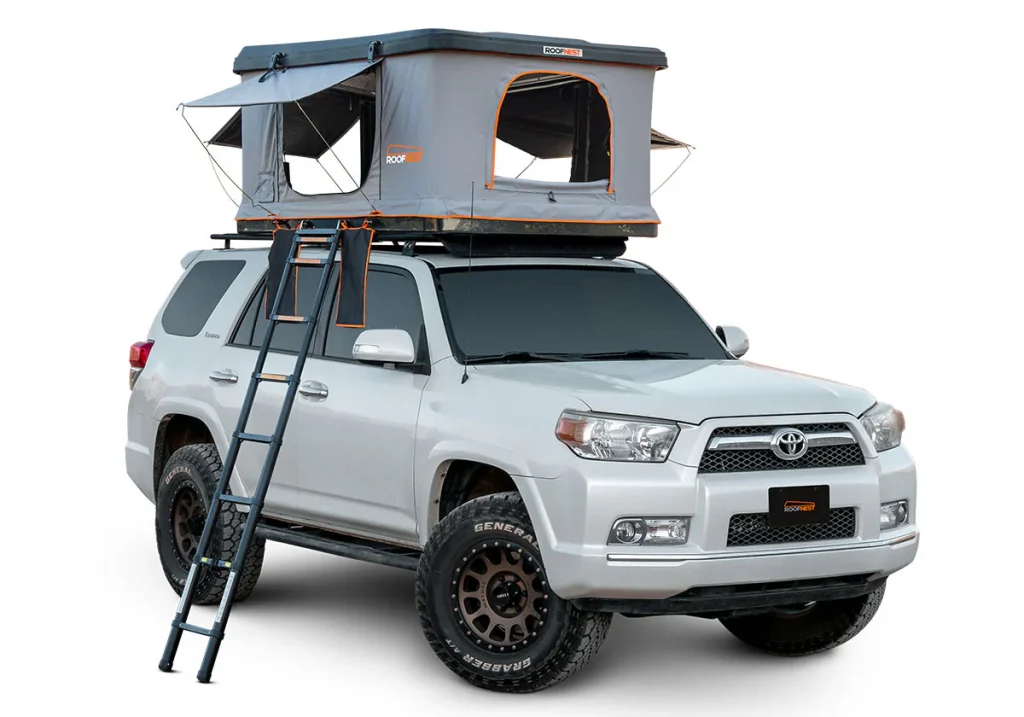
Overlanding is more than just off-roading—it’s about self-reliant travel to remote destinations where the journey matters as much as the destination. Whether you’re crossing deserts, weaving through dense forests, or exploring rugged mountain trails, one thing becomes clear: dependable navigation is absolutely essential. Unlike urban road trips, overlanding often takes you far beyond cellular coverage and standard road maps. That’s where specialized GPS and mapping tools come in. These tools not only help you stay on course but also enhance safety, planning, and the overall experience of venturing into the wild. In this guide, we’ll explore the best GPS systems, essential mapping features, and practical tips to help you confidently navigate your next overlanding adventure.
What Is Overlanding Navigation?
Overlanding is a style of travel that emphasizes exploration, self-sufficiency, and off-the-grid experiences—usually by vehicle or adventure motorcycle. It blends long-distance travel with camping, often taking explorers deep into nature, where conventional roads end and backcountry trails begin.
Importance of Reliable Navigation in Remote Areas
In remote landscapes, a missed turn or misread trail can quickly escalate into a dangerous situation. Without access to cellular networks or internet-based mapping, traditional navigation apps often fall short. Overlanding navigation tools are designed specifically for these challenges, offering offline capabilities, topographic data, and real-time location tracking to help adventurers avoid getting lost and make informed decisions in the field.
Offline vs. Online Navigation
Online navigation tools like Google Maps rely heavily on data connectivity, which makes them unreliable in wilderness areas. In contrast, overlanding navigation tools are built to function offline, using preloaded maps, GPS signals, and terrain overlays. While online tools can be helpful during the planning phase, offline-capable devices and apps are essential once you’re off-grid.
Why Specialized Overlanding Navigation Tools Matter
Navigating Off-Grid Trails and Backcountry Roads
Standard navigation apps often fall short when you’re far from paved roads and cell towers. Overlanding frequently involves exploring unmarked trails, forest service roads, and remote paths that don’t appear on conventional maps. Specialized navigation tools are equipped with detailed, up-to-date trail databases and offline maps tailored to these off-grid environments. They allow you to plan and follow routes where typical GPS apps would simply say, “no signal” or show a blank area. This level of detail is crucial when you’re deep in unfamiliar terrain and need accurate guidance.
Safety, Trip Planning, and Route Tracking
A quality overlanding navigation system does more than just point you in the right direction—it enhances your safety and planning efficiency. These tools let you pre-plan routes, estimate travel times based on terrain, and mark waypoints such as campsites, water sources, and fuel stops. They also record your travel path, which can be invaluable if you need to retrace your steps or share your route with others for safety purposes. Some devices even include SOS or emergency beacon integration, adding a critical safety net when things go wrong in isolated regions.
Topographical and Terrain Awareness
One of the most valuable features of overlanding navigation tools is topographical mapping. Unlike flat road maps, topographic maps show elevation changes, contour lines, rivers, and natural features that help you understand the lay of the land. This information is vital for identifying steep grades, potential water crossings, or impassable terrain. Some tools even offer 3D views or hill-shade layers, giving you a better sense of what lies ahead—crucial when you’re planning routes based on your vehicle’s capability and the physical challenge of the trail.
Weather and Hazard Alerts
Conditions in remote areas can change quickly and dramatically. Many modern overlanding GPS tools include weather integration features or can sync with services that provide up-to-date alerts. This allows you to receive warnings about severe weather, wildfires, floods, or trail closures. Being aware of environmental hazards in advance can help you make real-time decisions to reroute safely or set up camp before conditions worsen. This kind of foresight can turn a potentially dangerous situation into a manageable one.
Key Features to Look for in Overlanding Navigation Tools
Offline Maps and Satellite Imagery
When venturing off-grid, cellular coverage is often unreliable or completely unavailable. That’s why offline mapping is a non-negotiable feature in overlanding navigation tools. These maps can be pre-downloaded and include detailed road networks, trails, topography, and landmarks. Satellite imagery adds another layer of realism, offering a bird’s-eye view of terrain, vegetation, and obstacles that aren’t always visible on standard maps. Having both offline maps and satellite imagery ensures you’ll never lose your sense of direction—even in the most remote locations.
Real-Time GPS Tracking and Location Sharing
A built-in GPS receiver enables real-time tracking of your position without relying on an internet connection. This is critical for staying on course and making real-time decisions based on your location. Advanced tools also offer location sharing—allowing your travel companions or emergency contacts to monitor your position remotely. This is especially useful during group expeditions or when you’re traveling solo and want an added layer of security.
Custom Waypoint Marking and Route Planning
The ability to mark custom waypoints—like campsites, water sources, scenic lookouts, or hazards—is essential for effective trip planning. Most quality overlanding tools let you create, name, and organize these waypoints for easy navigation later. Coupled with route planning features, you can design personalized trails, calculate travel times, and adjust routes based on real-time conditions. These tools also allow route editing, re-routing, and importing GPX/KML files for added flexibility.
Topographic and 3D Mapping
Unlike flat road maps, topographic maps display elevation changes, terrain contours, and natural features—vital information when you’re navigating hills, valleys, rivers, or rugged passes. Some systems offer 3D mapping to provide a realistic view of terrain, helping you better assess routes and avoid impassable areas. These features are especially useful when planning multi-day trips or tackling technically challenging trails.
Rugged and Weather-Resistant Hardware
Overlanding conditions can be tough—mud, dust, rain, heat, and rough handling are all part of the journey. Your navigation hardware must be equally tough. Look for devices that are built to be shockproof, dustproof, and waterproof (IP67 or higher is ideal). A rugged build ensures your GPS system continues to perform even when your gear gets knocked around in rough terrain.
Long Battery Life or Solar Compatibility
Power sources can be limited during long overland journeys, so a navigation tool with long battery life is essential. Some units offer up to 12+ hours of continuous GPS use, and many are compatible with solar chargers or external battery packs. For extended trips, devices that allow for hot-swappable batteries or USB-C charging via a vehicle’s power supply offer added convenience and peace of mind.
Integration with Smartphones, Tablets, or Vehicle Dashboards
A good overlanding navigation system should offer cross-platform compatibility. Whether you’re using a dedicated GPS unit or a mobile app, the ability to sync data across smartphones, tablets, and even vehicle dashboards makes for a seamless experience. Bluetooth and Wi-Fi connectivity allow you to transfer routes, receive updates, and control functions remotely. Some systems also integrate with vehicle OBD-II systems to provide real-time vehicle diagnostics alongside your maps.
Best Overlanding Navigation Tools in 2025
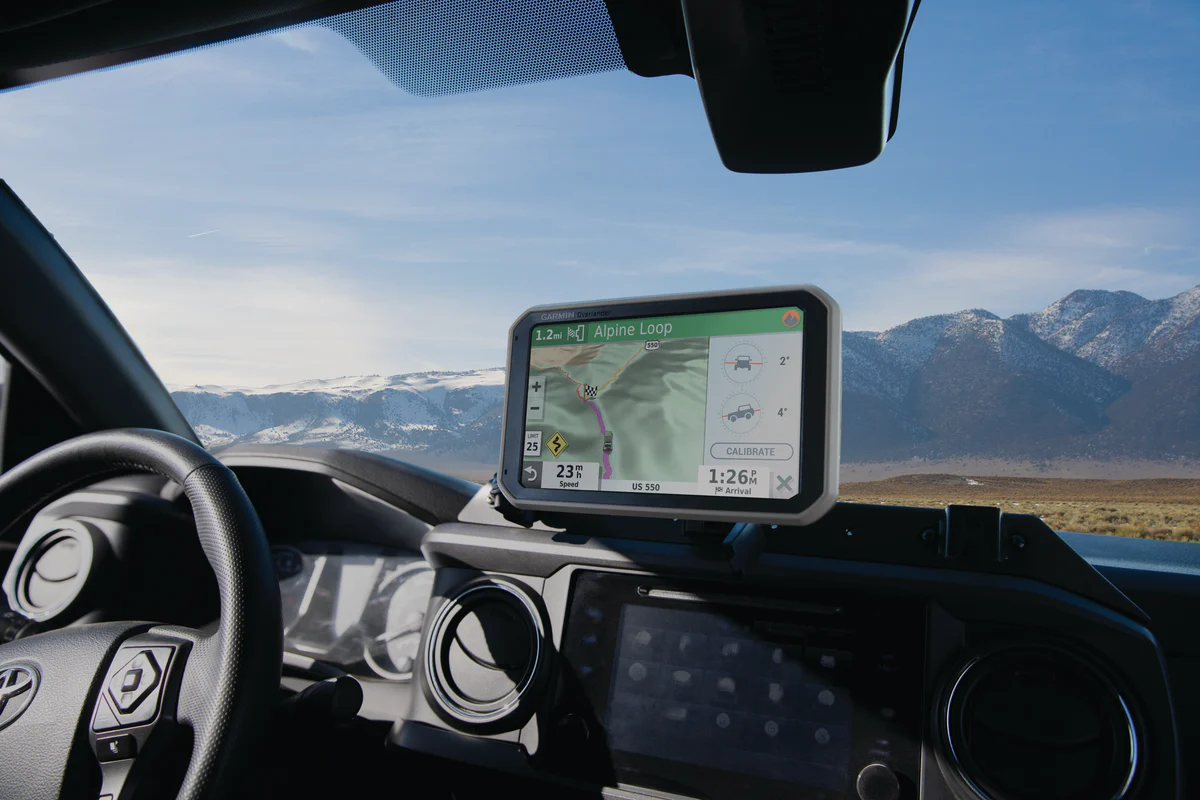
1. Garmin Overlander

The Garmin Overlander is a premium, all-in-one GPS device built specifically for overlanding enthusiasts. It comes preloaded with topographic maps, 4×4 trails, and detailed turn-by-turn directions—even when you’re completely offline. Designed to handle rough conditions, it features a rugged, weather-resistant casing and a bright 7-inch touchscreen that’s easy to read in sunlight.
Pros:
-
Built-in topographic maps for the U.S. and Canada
-
Offline routing and detailed trail coverage
-
Rugged design suitable for extreme environments
-
Compatible with Garmin inReach for satellite communication
Cons:
-
Higher price tag compared to other solutions
-
Limited app and mobile integration for some users
2. Gaia GPS
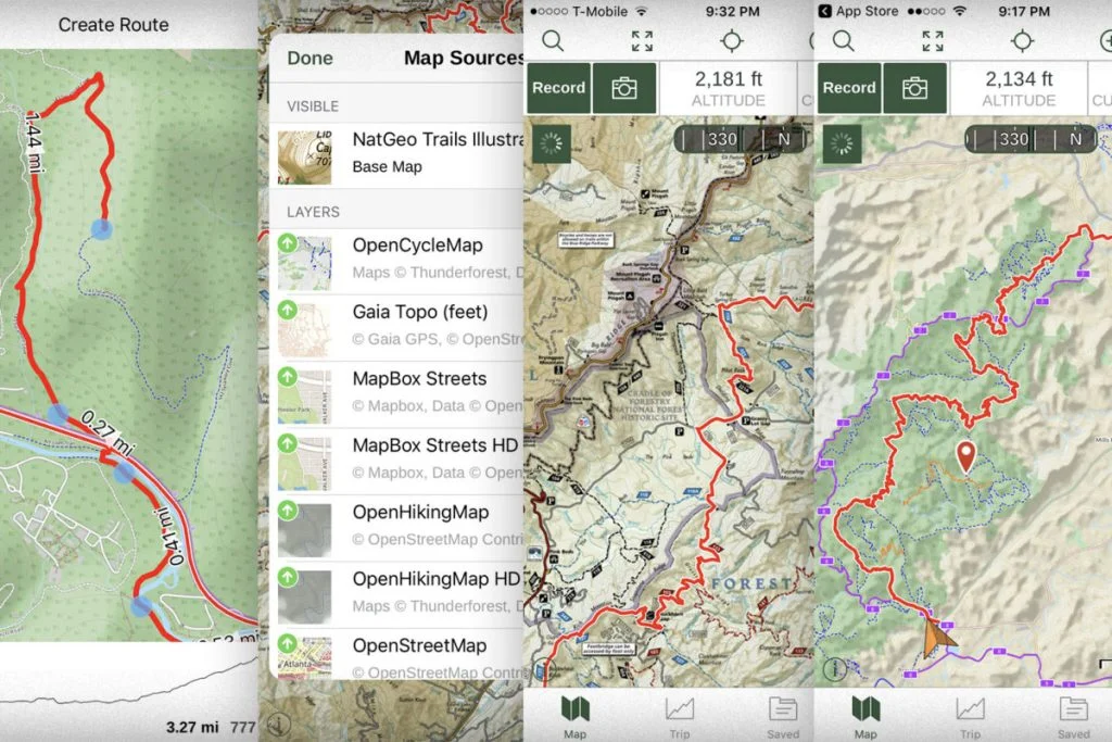
Gaia GPS is a powerful mapping app favored by hikers, off-roaders, and overlanders alike. It offers highly detailed topographical overlays, public land boundaries, offline access, and layered maps for different use cases. Available on both iOS and Android, it transforms smartphones or tablets into capable navigation tools.
Pros:
-
Rich topographical and terrain overlays
-
Allows saving and layering of multiple map types
-
Syncs across devices and works offline
-
Frequent updates and community trail sharing
Cons:
-
Advanced features require a paid subscription
-
Steep learning curve for first-time users
3. onX Offroad
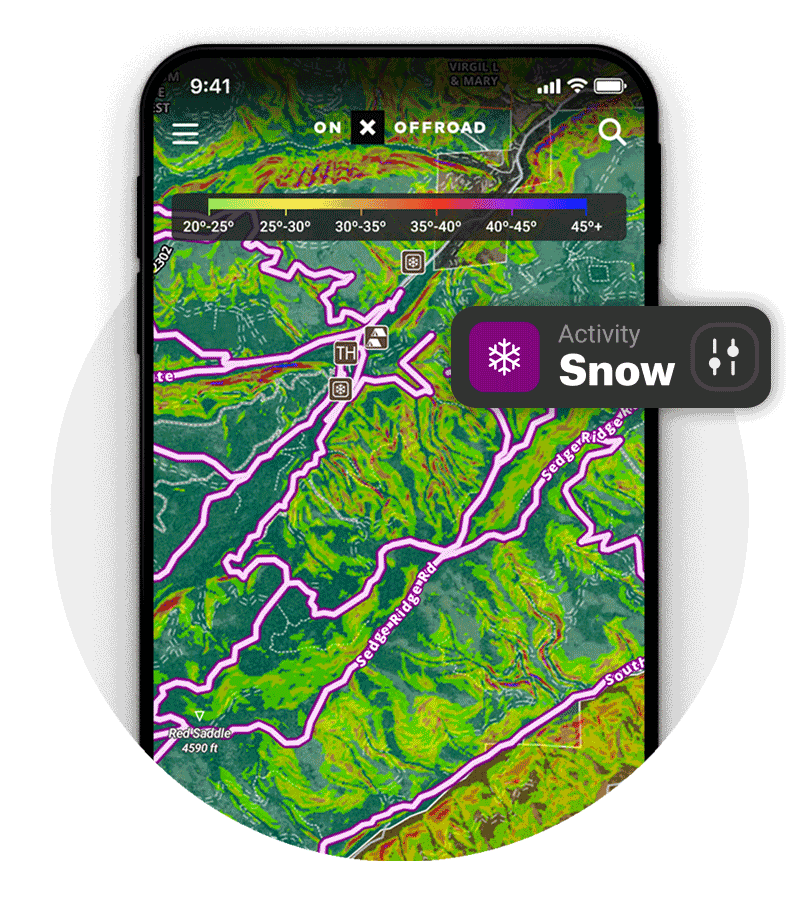
onX Offroad is designed with off-roaders in mind, offering real-time trail access, detailed land ownership maps (public vs. private), and mobile-friendly navigation. It’s especially useful in the U.S. where land access rights can be complex.
Pros:
-
Excellent trail data with difficulty ratings
-
Clear public/private land boundaries
-
User-friendly mobile interface
-
Ideal for scouting legal access and camping spots
Cons:
-
Core features are locked behind a subscription
-
Coverage is primarily U.S.-focused
4. Hema Maps HX-2
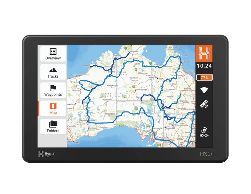
Hema Maps HX-2 is a dedicated GPS unit crafted for the Australian outback. It includes multiple map modes (street, touring, and 4WD), extensive topographic data, and access to Hema’s massive collection of off-road tracks.
Pros:
-
Tailored for Australia’s rugged terrain
-
Offline touring and 4×4 maps
-
Real-time tracking and multi-map switching
-
Simple interface with visual customization
Cons:
-
Limited usefulness outside Australia
-
Software updates can feel slow compared to app-based tools
5. Magellan TRX7 CS Pro
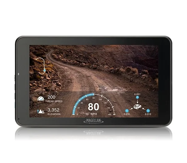
The Magellan TRX7 CS Pro is a robust GPS navigator built for serious trail explorers. It includes a large trail database, offline maps, and a built-in camera with geotagging capability. Its weatherproof design is ideal for tough overlanding environments.
Pros:
-
Preloaded with over 160,000 OHV routes
-
On-device trail recording and photo tagging
-
IP67-rated rugged construction
-
Large screen for easy visibility
Cons:
-
The interface may feel outdated and sluggish
-
Less intuitive software compared to newer apps
6. Avenza Maps
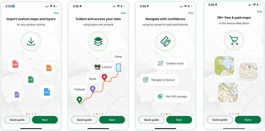
Avenza Maps is a lightweight and budget-friendly mobile app that supports geospatial PDFs. It’s a great tool for users who prefer using specific trail or park maps in digital format and want the ability to use them offline.
Pros:
-
Works with a wide range of PDF maps
-
Supports GPS tracking offline
-
Affordable, with many free maps available
-
Easy to use for basic navigation tasks
Cons:
-
No live turn-by-turn navigation
-
Limited in real-time data and advanced GPS features
Paper Maps and Compass: Still Worth Carrying?
When Digital Fails: Power, Weather, Tech Malfunctions
Even with today’s advanced GPS devices and mapping apps, overlanders should always carry paper maps and a reliable compass. Why? Digital tools, no matter how rugged or high-tech, are still vulnerable to battery drain, screen breakage, software glitches, or extreme weather conditions. If your GPS fails in the middle of a remote trail, a good paper map and compass can be the difference between finding your way back and getting seriously lost.
Suggested Paper Map Brands
Quality paper maps provide more than just roads—they offer topographic details, land boundaries, and essential points of interest. Some of the best brands to consider include:
-
National Geographic Trails Illustrated Maps – Durable, waterproof, and ideal for national parks and wilderness areas in the U.S.
-
Benchmark Road & Recreation Atlases – Known for their accuracy, elevation shading, and detail across Western U.S. states.
-
Hema Maps (Australia) – Excellent for Australian overlanders, covering 4WD tracks, terrain, and remote campsites.
Choose maps that are region-specific and scaled appropriately for navigation on foot or by vehicle.
Basics of Analog Navigation to Know
At a minimum, overlanders should know how to:
-
Read contour lines to understand elevation changes.
-
Use a compass with a map to find bearings and directions.
-
Identify landmarks and orient the map based on surroundings.
-
Plot a course using known coordinates or GPS waypoints as reference points.
-
Estimate travel time and distance without relying on a digital device.
Practicing these skills before your trip ensures you’re prepared if digital systems fail unexpectedly.
Tips for Planning Routes with Overlanding Navigation Tools
How to Pre-Load Maps for Offline Use
Before heading out, make sure to download all necessary maps for offline access. This includes:
-
Base road maps
-
Topographic overlays
-
Satellite imagery
-
Trail layers
Most tools (like Gaia GPS, onX Offroad, or Avenza Maps) allow you to select specific map areas to download based on your route. Always verify downloads are complete and accessible in airplane mode before departing.
Creating Custom Trails and Marking Hazards
Custom route creation allows you to:
-
Plot precise trails using GPS coordinates or waypoints.
-
Mark known hazards (like river crossings, washouts, or steep sections).
-
Identify potential campsites, fuel stops, or scenic detours.
-
Add notes or photos to specific map points.
These personalized maps make navigation smoother and safer, especially when revisiting the area later.
Syncing Across Devices for Group Navigation
Many apps offer cloud sync features, letting you share routes, waypoints, and live locations across devices. This is especially useful for group travel, where coordination between vehicles is essential. Tools like Garmin Explore, Gaia GPS, and onX Offroad support multi-user route sharing and live tracking when connected.
Downloading Weather and Elevation Layers
For the most informed navigation, download additional map layers before your trip:
-
Weather overlays show temperature, precipitation, and storm alerts.
-
Elevation and slope maps help identify steep grades and plan altitudes.
These layers enhance your ability to plan safe travel times, avoid bad weather, and anticipate physical demands on both your vehicle and yourself.
Final Thoughts
Choosing the right navigation tools is not just about convenience—it’s a critical part of safe and successful overlanding. When you’re miles away from civilization, reliable GPS systems, detailed offline maps, and real-time tracking features become your lifeline. These tools allow you to confidently explore unfamiliar terrain, avoid hazards, and stay on course, even when the unexpected happens.
However, no single tool is foolproof. That’s why a combination of digital and analog navigation is always recommended. GPS units and mobile apps offer dynamic planning and real-time data, while paper maps and a compass provide a reliable backup when electronics fail. Mastering both methods ensures you’re prepared for any situation.
Finally, don’t forget to support your digital tools with backup power solutions, such as portable battery packs or solar chargers. Long battery life is essential when you’re off the grid for extended periods, and solar compatibility can keep your devices running no matter how far you roam.
Whether you’re a seasoned overlander or just starting your journey, investing in the right navigation gear can make your trips safer, more efficient, and far more enjoyable.
Read More: Solar Power: Buyer’s Guide for Overlanding Energy Solutions